
Static plotting for spatial data.
Verified details
These details have been verified by PyPIProject links
Owner
GitHub Statistics
Maintainers


Project description
spatialdata-plot: rich static plotting from SpatialData objects






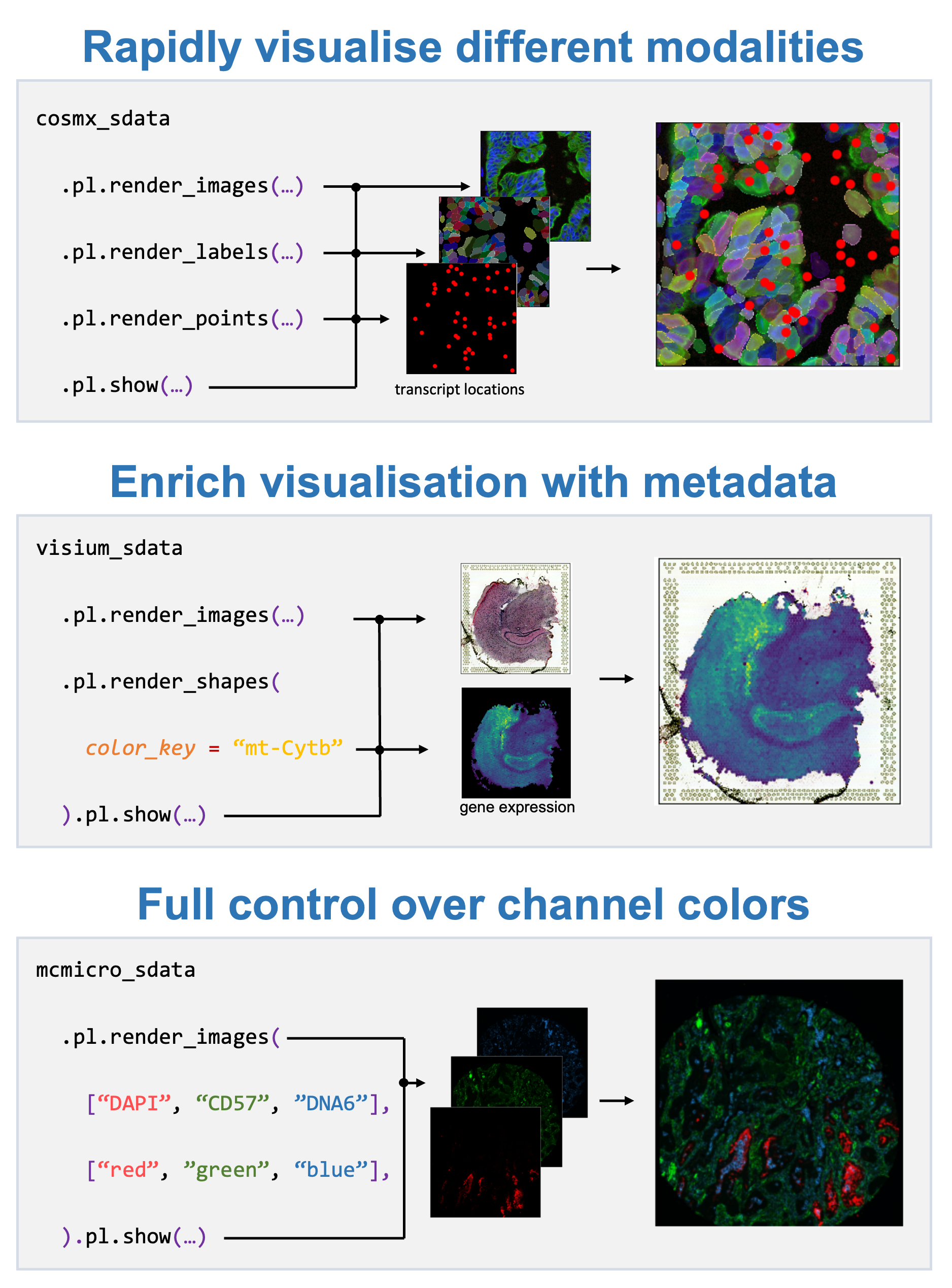
The spatialdata-plot package extends spatialdata with a declarative plotting API that enables to quickly visualize spatialdata objects and their respective elements (i.e. images, labels, points and shapes).
SpatialData’s plotting capabilities allow to quickly visualise all contained modalities. The user can specify which elements should be rendered (images, labels, points, shapes) and specify certain parameters for each layer, such as for example the intent to color shapes by a gene’s expression profile or which color to use for which image channel. When the plot is then eventually displayed, all transformations, alignments and coordinate systems are internally processed to form the final visualisation. In concordance with the general SpatialData philosophy, all modalities of the major spatial technologies are supported out of the box.
Getting started
For more information on the spatialdata-plot library, please refer to the documentation. In particular, the
- Gallery — executable example notebooks demonstrating the plotting capabilities.
- API documentation.
- SpatialData example notebooks (section "Visualizations") for plotting in the context of broader analyses.
Installation
You need to have Python 3.10 or newer installed on your system. If you don't have Python installed, we recommend installing Mambaforge.
There are several alternative options to install spatialdata-plot:
- Install the latest release of
spatialdata-plotfromPyPI <https://pypi.org/project/spatialdata-plot/>_:
pip install spatialdata-plot
- Install the latest development version:
pip install git+https://github.com/scverse/spatialdata-plot.git@main
Contact
For questions and help requests, you can reach out in the scverse discourse. If you found a bug, please use the issue tracker.
Citation
Marconato, L., Palla, G., Yamauchi, K.A. et al. SpatialData: an open and universal data framework for spatial omics. Nat Methods (2024). https://doi.org/10.1038/s41592-024-02212-x
spatialdata-plot is part of the scverse® project (website, governance) and is fiscally sponsored by NumFOCUS. If you like scverse® and want to support our mission, please consider making a tax-deductible donation to help the project pay for developer time, professional services, travel, workshops, and a variety of other needs.

Project details
Verified details
These details have been verified by PyPIProject links
Owner
GitHub Statistics
Maintainers
Release history Release notifications | RSS feed


Download files
Download the file for your platform. If you're not sure which to choose, learn more about installing packages.
Source Distribution
Built Distribution
Filter files by name, interpreter, ABI, and platform.
If you're not sure about the file name format, learn more about wheel file names.
Copy a direct link to the current filters
File details
Details for the file spatialdata_plot-0.4.0.tar.gz.
File metadata
- Download URL: spatialdata_plot-0.4.0.tar.gz
- Upload date:
- Size: 19.0 MB
- Tags: Source
- Uploaded using Trusted Publishing? Yes
- Uploaded via: twine/6.1.0 CPython/3.13.12
File hashes
| Algorithm | Hash digest | |
|---|---|---|
| SHA256 |
2f92664fdfe7b6e91d1d1563a5468a78fd980e3369e85ae7dd8bd812ab16e0ed
|
|
| MD5 |
ad3f339024cd5630cd328f77094ae86d
|
|
| BLAKE2b-256 |
b04ccf5b141a624d09f6dbcae67d4fac611824a8c922834a5afb5d31b236dbdc
|
Provenance
The following attestation bundles were made for spatialdata_plot-0.4.0.tar.gz:
Publisher:
release.yaml on scverse/spatialdata-plot
-
Statement:
-
Statement type:
https://in-toto.io/Statement/v1 -
Predicate type:
https://docs.pypi.org/attestations/publish/v1 -
Subject name:
spatialdata_plot-0.4.0.tar.gz -
Subject digest:
2f92664fdfe7b6e91d1d1563a5468a78fd980e3369e85ae7dd8bd812ab16e0ed - Sigstore transparency entry: 1644245059
- Sigstore integration time:
-
Permalink:
scverse/spatialdata-plot@55eab64cc7cdfa343d649636fdbe12c46b83036e -
Branch / Tag:
refs/tags/v0.4.0 - Owner: https://github.com/scverse
-
Access:
public
-
Token Issuer:
https://token.actions.githubusercontent.com -
Runner Environment:
github-hosted -
Publication workflow:
release.yaml@55eab64cc7cdfa343d649636fdbe12c46b83036e -
Trigger Event:
release
-
Statement type:
File details
Details for the file spatialdata_plot-0.4.0-py3-none-any.whl.
File metadata
- Download URL: spatialdata_plot-0.4.0-py3-none-any.whl
- Upload date:
- Size: 114.8 kB
- Tags: Python 3
- Uploaded using Trusted Publishing? Yes
- Uploaded via: twine/6.1.0 CPython/3.13.12
File hashes
| Algorithm | Hash digest | |
|---|---|---|
| SHA256 |
e64b713e97d05caf84516007002739c38b84bbd59450424f0c2d83593179b1ed
|
|
| MD5 |
0cbe05efcbdbfcbfff339a41e859daaa
|
|
| BLAKE2b-256 |
b7b8ab2141c09b5eda2b13c727d8ddaff56f364f41a2127f30260199629c65dc
|
Provenance
The following attestation bundles were made for spatialdata_plot-0.4.0-py3-none-any.whl:
Publisher:
release.yaml on scverse/spatialdata-plot
-
Statement:
-
Statement type:
https://in-toto.io/Statement/v1 -
Predicate type:
https://docs.pypi.org/attestations/publish/v1 -
Subject name:
spatialdata_plot-0.4.0-py3-none-any.whl -
Subject digest:
e64b713e97d05caf84516007002739c38b84bbd59450424f0c2d83593179b1ed - Sigstore transparency entry: 1644245242
- Sigstore integration time:
-
Permalink:
scverse/spatialdata-plot@55eab64cc7cdfa343d649636fdbe12c46b83036e -
Branch / Tag:
refs/tags/v0.4.0 - Owner: https://github.com/scverse
-
Access:
public
-
Token Issuer:
https://token.actions.githubusercontent.com -
Runner Environment:
github-hosted -
Publication workflow:
release.yaml@55eab64cc7cdfa343d649636fdbe12c46b83036e -
Trigger Event:
release
-
Statement type:






