
olmoearth_inferenceX
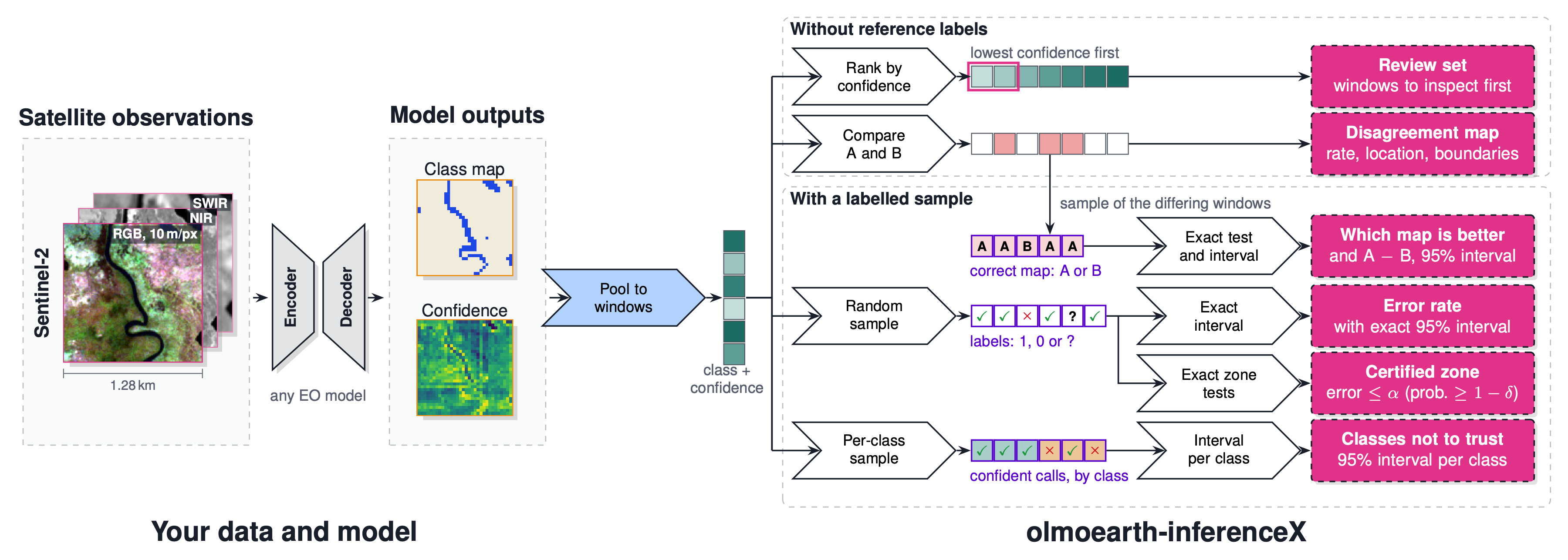
Checks an Earth-observation map after inference: where it is likely wrong, how wrong it is, which part you can trust, and which of two maps is better.
It reads only the per-class scores a model writes out. It never runs the model and needs no torch, so it works on OlmoEarth's outputs, on other models' maps and on published products with a confidence layer, whatever the imagery type: Sentinel-1, Sentinel-2, Landsat, or other satellites. (Tested so far on maps made from Sentinel-1, Sentinel-2 and Landsat.)
Documentation: https://olmoearth-inferencex.readthedocs.io/
Install
pip install "olmoearth-inferencex[geo]"    # Python 3.11 to 3.13; without [geo] it reads .npy only
oe-inferencex demo                          # a real Dynamic World tile; needs no data
What it answers
| Question | Commands | Labels |
|---|---|---|
| Where do I look first? | assess scores.tif --out audit |
none |
| How wrong is the map? | sample scores.tif --budget 400 --design random --out to_label.csv, fill in wrong, then estimate to_label.csv |
about 400 random windows |
| Which part can I trust? | certify to_label.csv --alpha 0.05 |
the same windows |
| Which class does the map draw wrong? | add a reference_class column (the class you see), then estimate to_label.csv --per-class |
the same windows for a large class; about 900 for a 5% class drawn at half, thousands at 1% (plan --class-share) |
| Which of two maps is more accurate? | sample a.tif --other b.tif --budget 100 --out pairs.csv, fill in reference_class, then estimate pairs.csv |
about 100, where the maps differ |
| Which class's confident calls can't I trust? | sample scores.tif --design audit --per-class 20 --out audit.csv, fill in reference_class, then estimate audit.csv --alpha 0.05 |
about 20 per class |
| Where do two maps differ? | compare a.tif b.tif --out diff |
none |
Every command starts with oe-inferencex. The input is the model's per-class scores before the argmax, as a GeoTIFF
or a .npy array of shape (C, H, W). plan says how many labels a question needs and --help lists each command's
options. The quick start runs each one on
a test map.
Examples
Where do I look first? Dynamic World, a land-cover map made from Sentinel-2, on one tile in southern Peru. No labels are used to pick the windows; the expert's labels only show how it did.
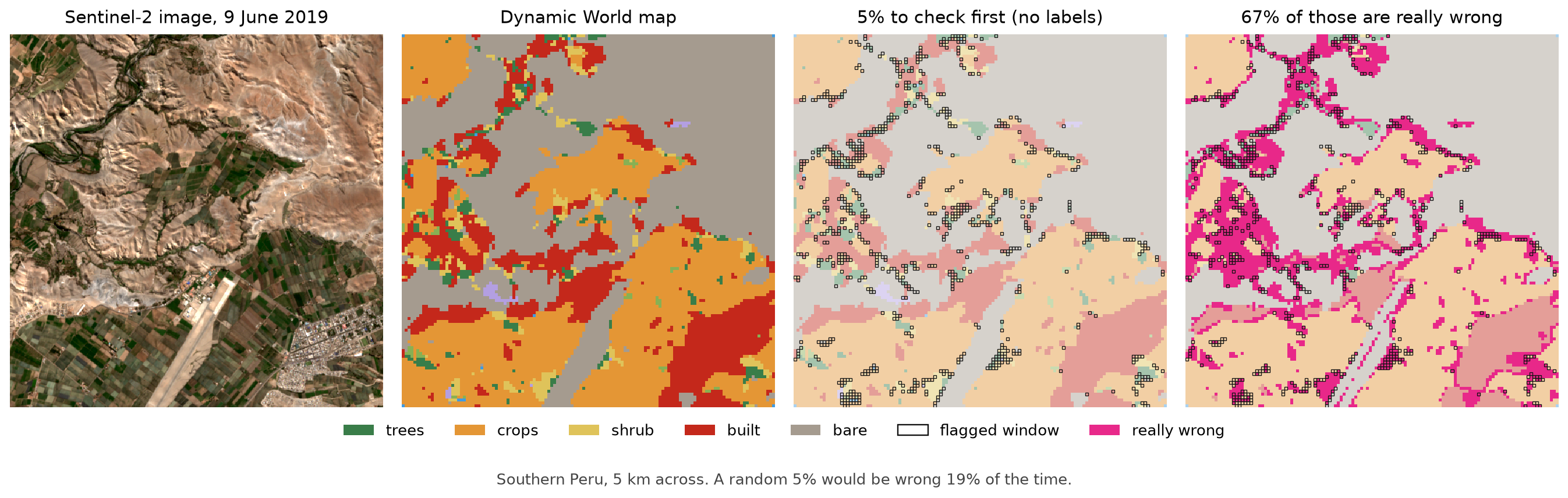
The 5% it flags first are wrong 67% of the time. A random 5% would be wrong 19% of the time.
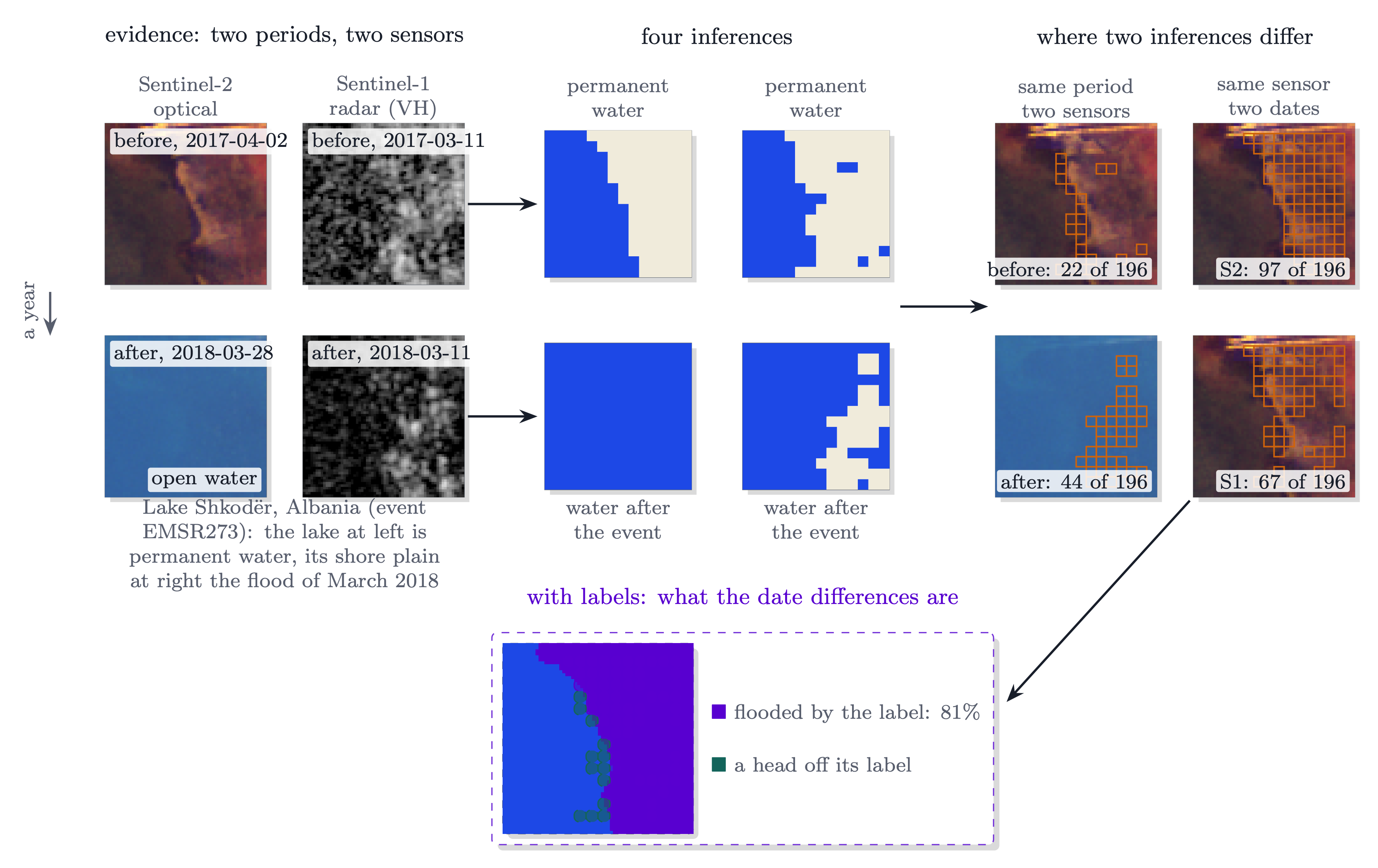
Where do two maps differ? A flood at Lake Shkodër, Albania, in March 2018 (Copernicus EMS activation EMSR273), seen by Sentinel-2 and Sentinel-1.
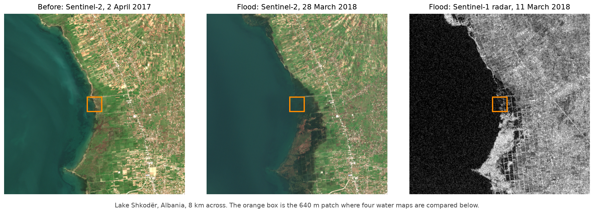
Inside the orange box, water mapped from each sensor before and after (imagery from GEOID-Flood and WorldFloods v2); orange squares are where two maps disagree:
Which of two maps is more accurate? Fields of the World's global field map (FTW, 2nd edition) beside a second model, PRUE B3, on a test chip of the FTW benchmark in Croatia.
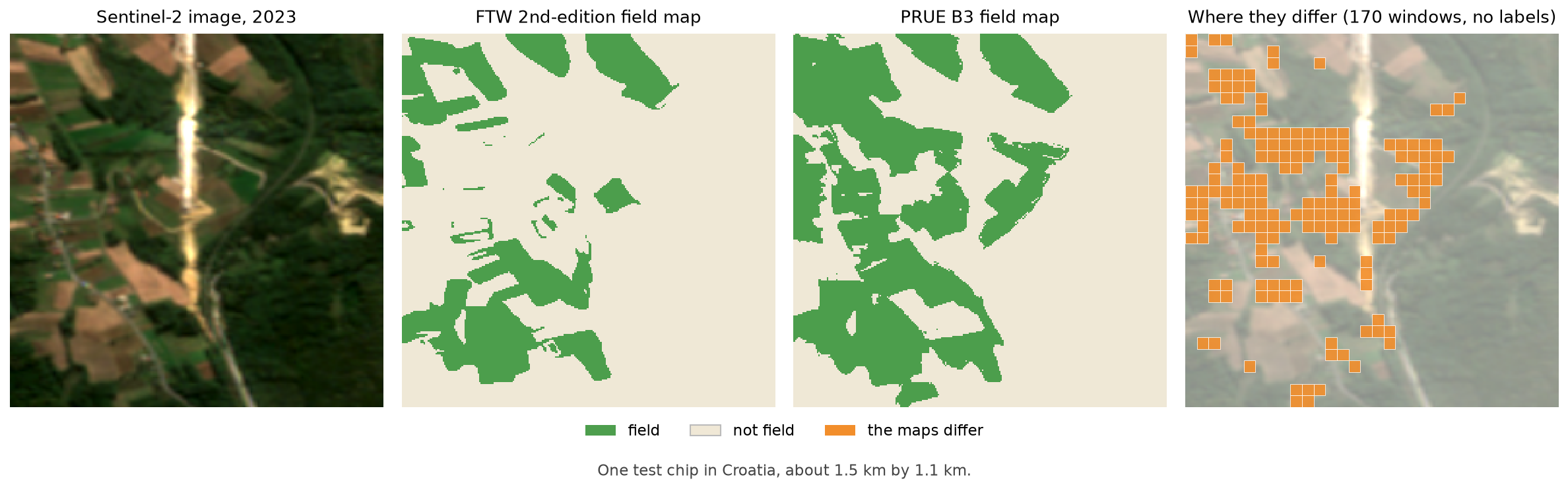
Across Croatia's 353 test chips the two maps differ at 13% of windows. There FTW agrees with the benchmark 74% of the time, and labelling 100 of those windows names FTW the better map 99.9% of the time. In Belgium and Sweden, B3 was the better one.
Imagery: contains modified Copernicus Sentinel data (2017 to 2023). Dynamic World map and expert labels: Brown et al., Scientific Data, 2022, CC BY 4.0. FTW map: Fields of the World, CC BY 4.0. How the figures were made is in docs/figures/examples.
Limits
- Without labels it tells you where to look, not how wrong the map is.
- In a new place or year the ranking can weaken. Check it with a few labels.
- When two legends draw a class boundary differently (grass or shrub, say), only labels find those errors.
- Intervals and certified zones assume the labels are right.
- If parts of the map were made from different inputs (clouds, a missing sensor), use
--condition. - Labelling more and rerunning counts as a new test, unless you use a sequential sample.
Use from an agent
oe-inferencex mcp is a local MCP server; nothing is hosted. Add it to any MCP client as the command
uvx --from "olmoearth-inferencex[geo,mcp]" oe-inferencex mcp, for example in Claude Code:
claude mcp add --scope user oe-inferencex -- uvx --from "olmoearth-inferencex[geo,mcp]" oe-inferencex mcp
Use a capable model; smaller ones dropped the limits the tools state. To try it, write the demo tile into an empty folder, start the agent there and ask:
uvx --from olmoearth-inferencex oe-inferencex demo
Where should I look first in oe_inferencex_demo/sample_probabilities.npy? Use windows of 1 pixel, and grade the order against oe_inferencex_demo/sample_truth.npy.
More
- Every result, its limits and the technical report: the research record.
- Development: clone the repository, then
uv syncanduv run pytest. - Apache License 2.0 (LICENSE); cite with CITATION.cff; questions in GitHub issues.
1 maintainer

Metadata
1 maintainer
Release files for olmoearth-inferencex 1.14.0
For a detailed explanation of source distributions (sdists) and built distributions (wheels), please see the package formats documentation.
Source distribution (sdist)
| File | Size | Uploaded | Provenance | |
|---|---|---|---|---|
| olmoearth_inferencex-1.14.0.tar.gz | 534.4 kB | Without provenance | Details |
Built distribution (wheel)
| File | Interpreter | ABI | Platform | Reset |
|---|---|---|---|---|
| olmoearth_inferencex-1.14.0-py3-none-any.whl | Python 3 | none | any | Details |
Total release size: 1.1 MB
Release files / olmoearth_inferencex-1.14.0.tar.gz
| Download URL | olmoearth_inferencex-1.14.0.tar.gz |
|---|---|
| Size | 534.4 kB |
| Tags | Source |
|
SHA-256 checksum How to use checksums |
e8901b904742cd4443bf43cb795776574429762ba2414ab732f60b6d62021a80
|
|
BLAKE2b-256 checksum How to use checksums |
a443e1a90004f45402e1ea9654abf97a9b5def94d8081bb9ac73ea106bb5bc57
|
| Upload date | |
|
Uploaded using Trusted Publishing? What is trusted publishing? |
Yes |
| Uploaded via |
uv/0.13.5 {"installer":{"name":"uv","version":"0.13.5","subcommand":["publish"]},"python":null,"implementation":{"name":null,"version":null},"distro":{"name":"Ubuntu","version":"24.04","id":"noble","libc":null},"system":{"name":null,"release":null},"cpu":null,"openssl_version":null,"setuptools_version":null,"rustc_version":null,"ci":true}
|
Release files / olmoearth_inferencex-1.14.0-py3-none-any.whl
| Download URL | olmoearth_inferencex-1.14.0-py3-none-any.whl |
|---|---|
| Size | 539.2 kB |
| Tags | Python 3 |
|
SHA-256 checksum How to use checksums |
c40238359d6297cd420269a514058fde0efb3c0d8f5f0002d14846f7df006d2a
|
|
BLAKE2b-256 checksum How to use checksums |
066c7113d22d9fbefc08534e5ab4fdb728a408e31a57a54cad20868bd532eae8
|
| Upload date | |
|
Uploaded using Trusted Publishing? What is trusted publishing? |
Yes |
| Uploaded via |
uv/0.13.5 {"installer":{"name":"uv","version":"0.13.5","subcommand":["publish"]},"python":null,"implementation":{"name":null,"version":null},"distro":{"name":"Ubuntu","version":"24.04","id":"noble","libc":null},"system":{"name":null,"release":null},"cpu":null,"openssl_version":null,"setuptools_version":null,"rustc_version":null,"ci":true}
|
Security for olmoearth-inferencex 1.14.0
Provenance
Provenance describes where a file came from. On PyPI, provenance is shared via attestations, which provide a verifiable record of the build or publishing details. View details, limitations and caveats.
No provenance found
None of the files in this release were uploaded with provenance metadata.
A note on package security
PyPI is a repository for distributing packages, not a service for auditing them. While third-party security researchers and our staff do their best to detect and remove malicious packages, PyPI cannot guarantee the quality, security or suitability of any given package.
To learn more about protecting yourself from malicious actors, visit our package security documentation.














