
linecast
Weather, tides, the sun, the moon, and maps, drawn for the terminal. The Old Farmer's Almanac meets Minitel.



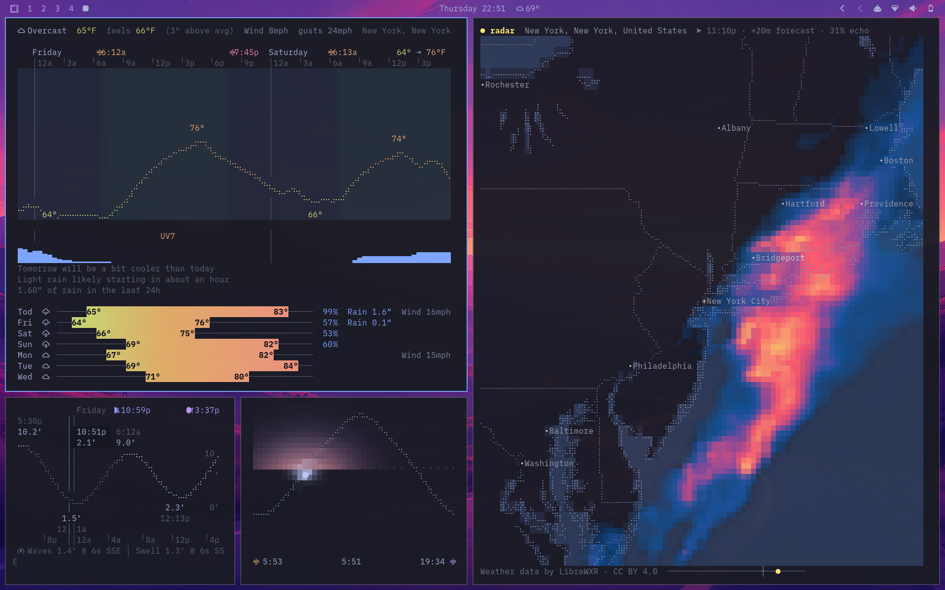
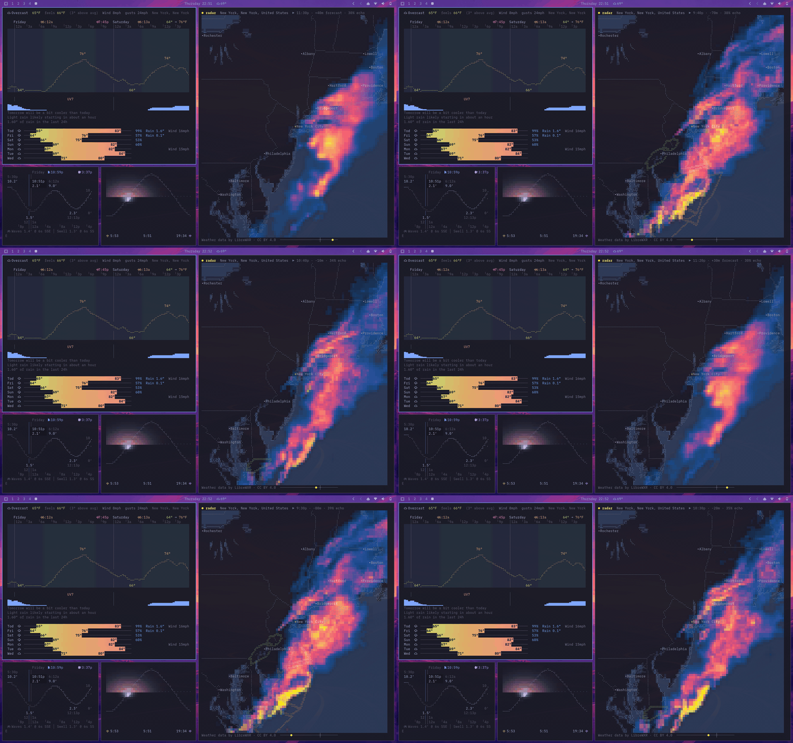
linecast turns free public data into six live, mouse-friendly terminal apps for macOS, Linux, and Windows. It is pure Python with no third-party dependencies (two on Windows), tries to match your terminal theme, and needs no accounts or API keys.
| Command | What it shows |
|---|---|
linecast weather |
Current conditions, an hourly braille temperature curve, a seven-day forecast, air quality, how today compares with a normal day, and official alerts |
linecast sunshine |
The sun on its daily arc, with the color of the sky, day length, and moon phase |
linecast moon |
The moon as seen from where you are, with illumination, altitude, rise and set times, and the next full and new moons |
linecast tides |
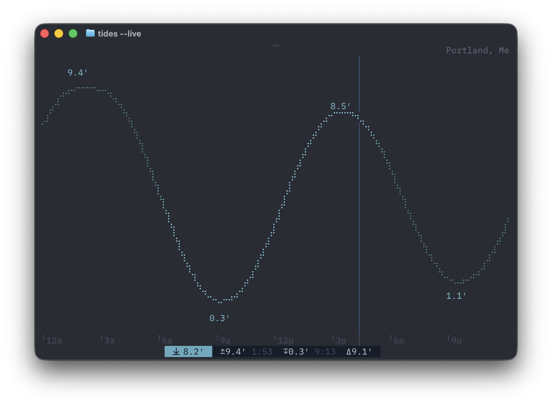
A tide curve shaded by daylight, the current water level, and the times of high and low tide |
linecast radar |
Animated radar or satellite imagery for the whole world, warning polygons, temperature, and wind |
linecast maps |
Street maps, terrain, and a globe you can spin, with live daylight and clouds, place search, and directions |
Install
brew install linecast
Or with uv:
uv tool install linecast
pipx install linecast and pip install linecast work too, and there are community-maintained packages in the AUR and in nixpkgs (unstable channel, for now). linecast needs Python 3.10 or newer on macOS, Linux, or Windows.
To try it before installing anything:
uvx linecast weather
Or with nothing but curl — get.sh runs linecast with whatever the machine has, down to plain python3:
curl -sL https://raw.githubusercontent.com/ashuttl/linecast/main/get.sh | sh
It opens weather; name another tool with sh -s sunshine, or pass flags with sh -s -- --metric.
On Windows
Use Windows Terminal; Git Bash and mintty see a pipe rather than a terminal, so they get static output. The install adds two packages: tzdata, because Windows has no IANA time zone database, and truststore, for TLS verification through the OS certificate store. Icons default to emoji in Windows Terminal; with a Nerd Font installed and selected, linecast icons nerd switches to the full set.
Using it
Every command opens in live mode when run in a terminal, set to where your IP address says you are unless you have saved a location.
linecast weather --location "Québec"
linecast radar --location 41.88,-87.63
linecast maps --view terrain --location "Innsbruck"
linecast maps --to "Portland Head Light" --profile bike
--print gives one static frame, and piped output gets one automatically. Weather, sunshine, moon, and tides also have --json, and a short --oneline for status bars.
A closer look
Weather
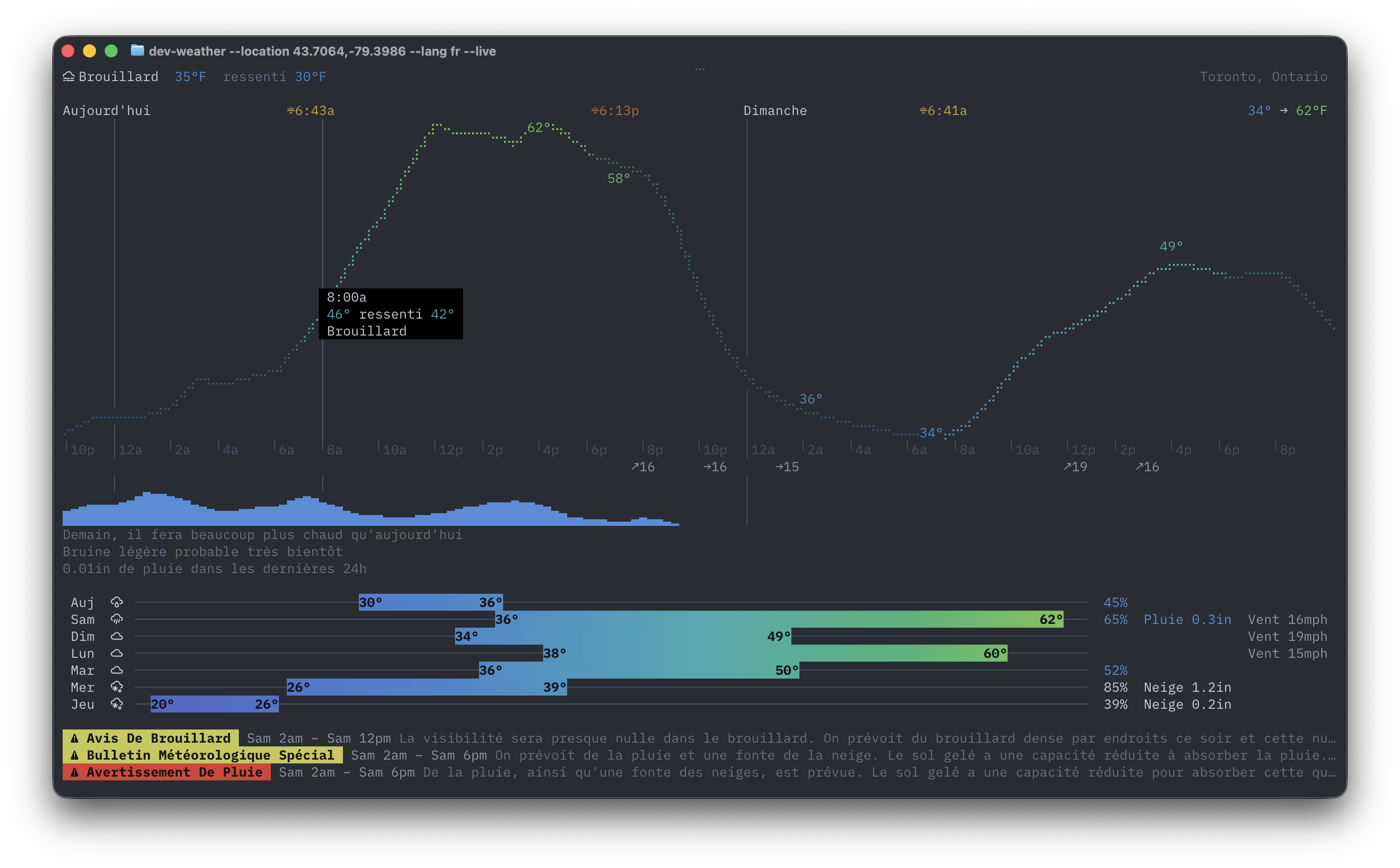
The dashboard combines current conditions, hourly temperatures shaded by daylight, precipitation, daily ranges, air quality, and a line on how today compares with a normal day. Official alerts cover 45 countries; click one to read it in full, or press o to open it in your browser. In India, air quality is shown on the CPCB's National AQI scale.
Sunshine and Moon
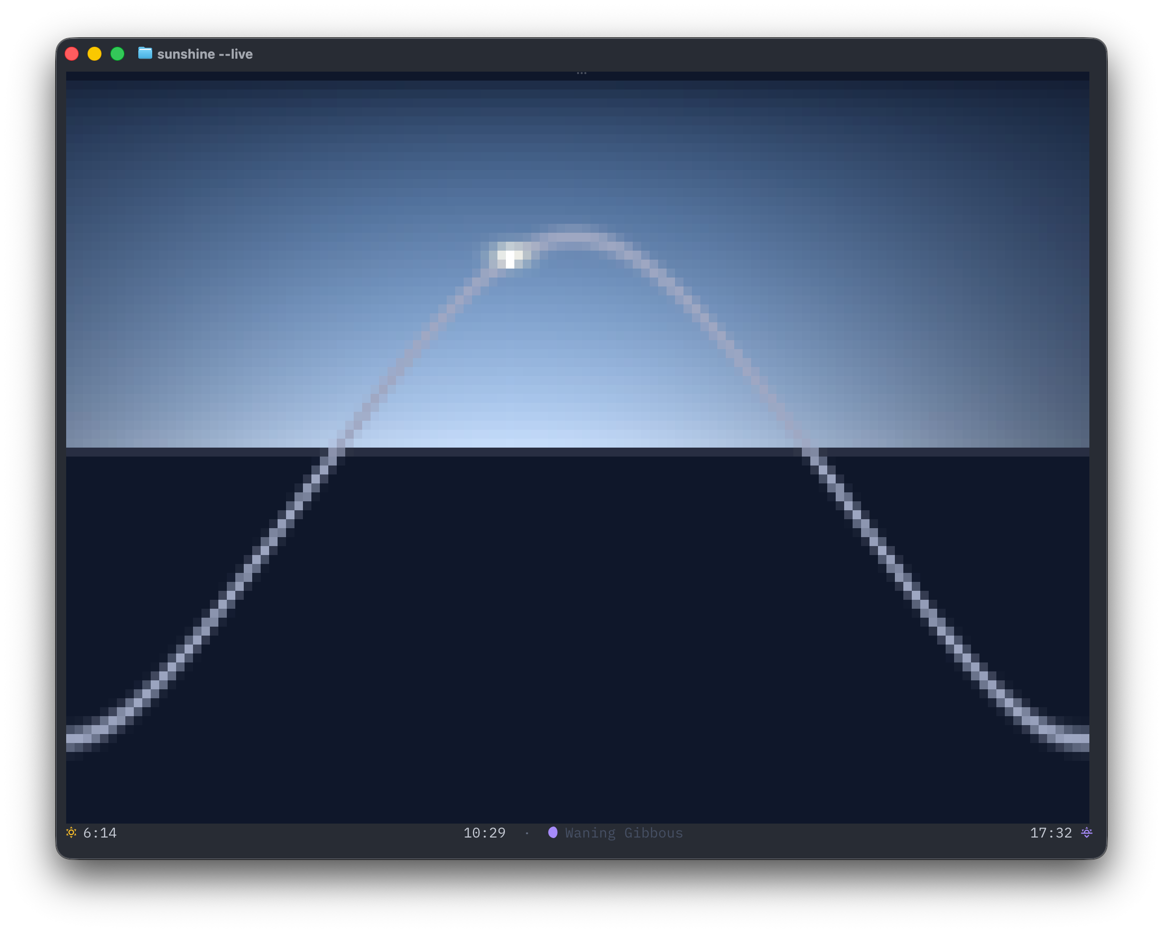
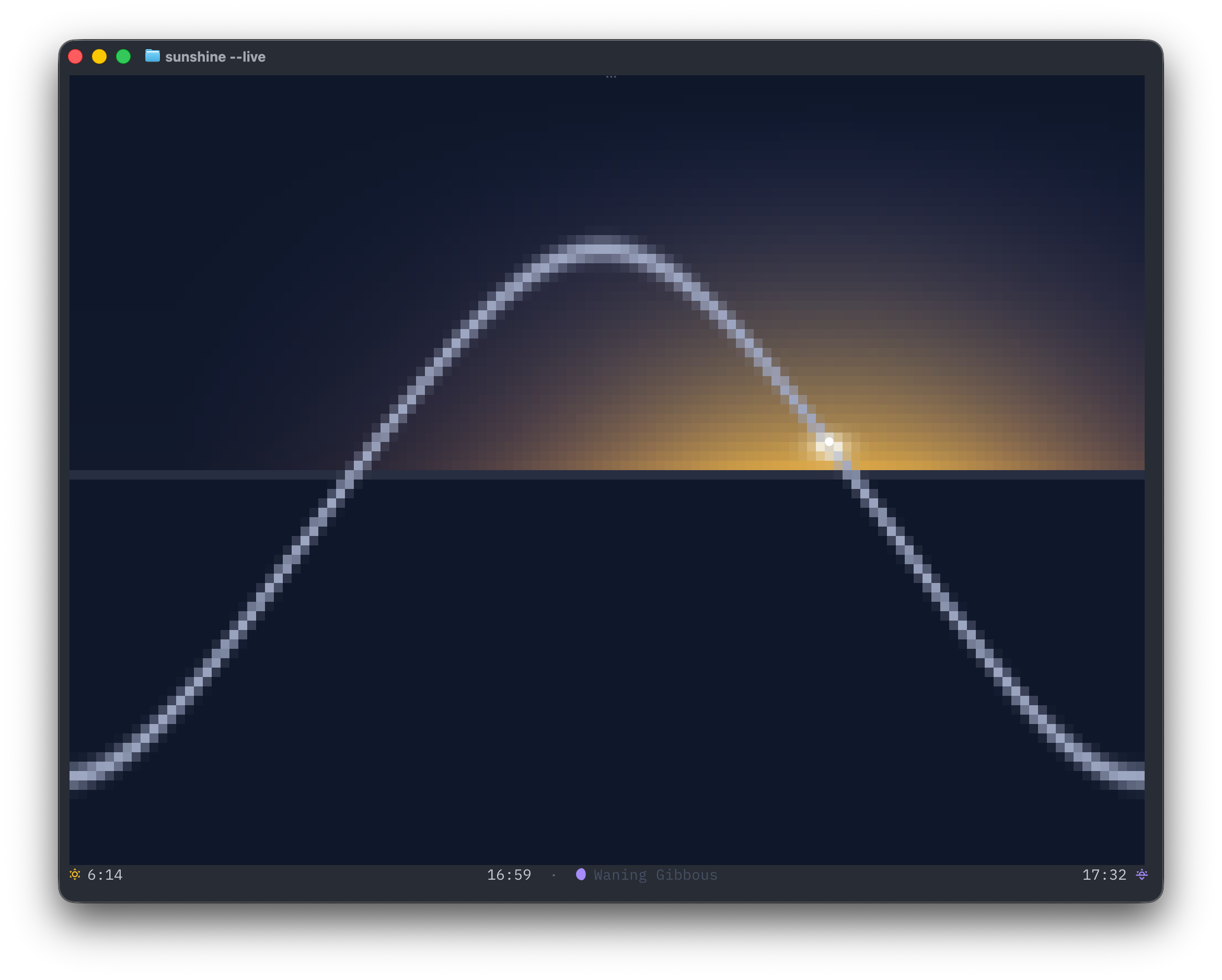
sunshine is inspired by the Apple Watch Solar face. The arc and sky move through dawn, day, dusk, and night, and the day length comes with how much longer or shorter it is than yesterday.
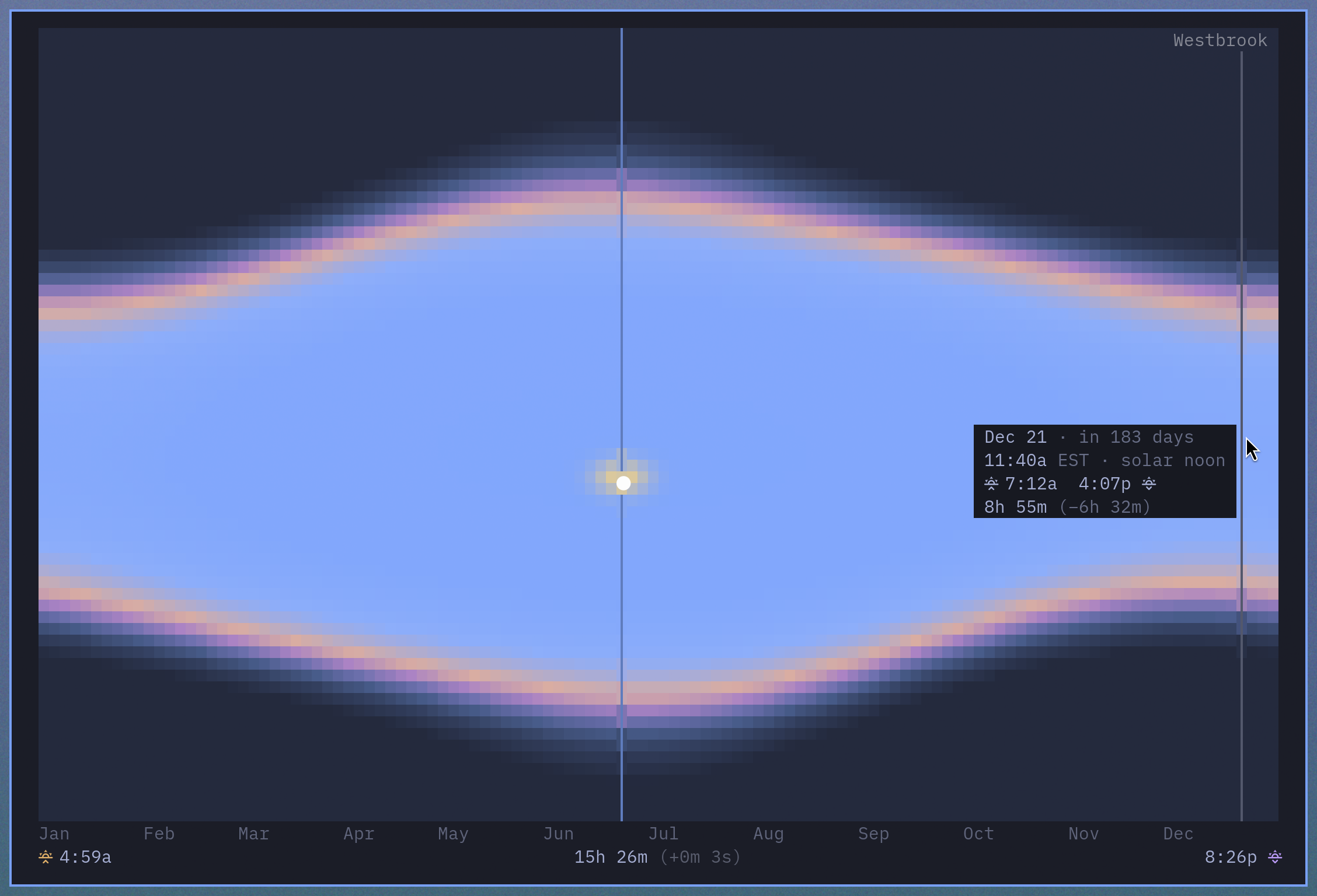
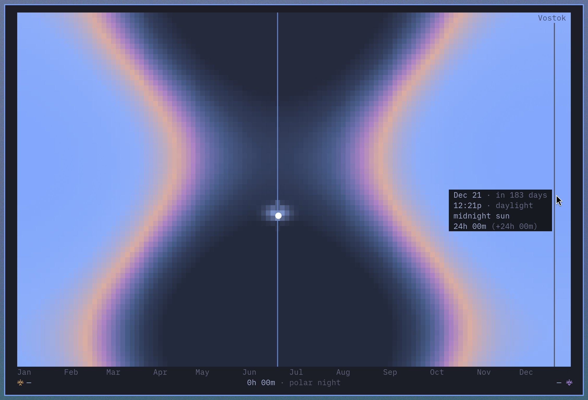
linecast sunshine --year draws a whole year instead of one day. Each column is a day, running from midnight at the top to midnight at the bottom, and every point in it takes the color of the sky at that hour. Sunrise and sunset emerge where the night colors meet the day colors. Hover over a day to see its sunrise, sunset and day length, along with the time and the sky under the pointer. In live mode, v (or y) switches between the day view and the year view. --dst plots each day in its own clock, so the clock changes show as steps.
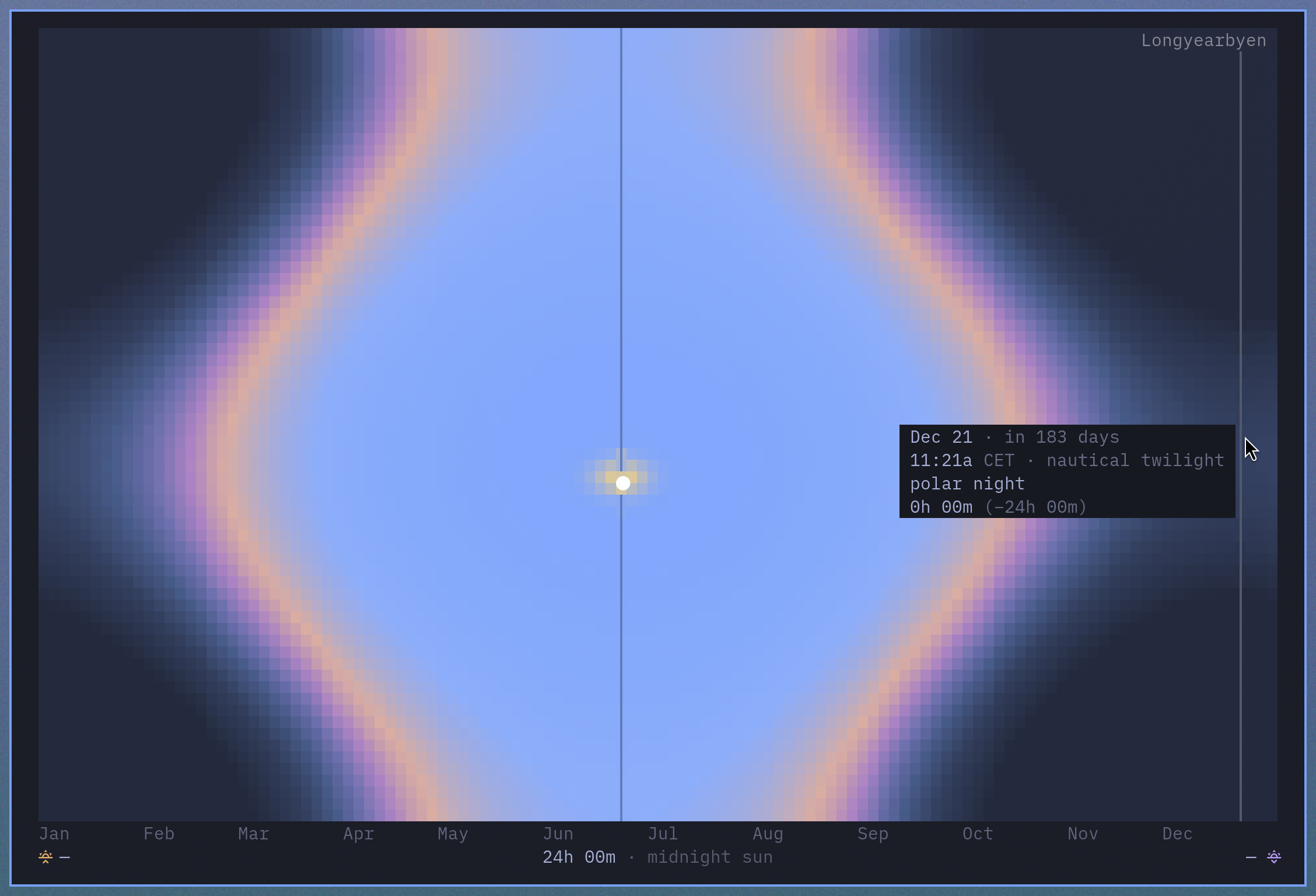
Near the poles the same chart turns into polar night and midnight sun. These are Longyearbyen and Vostok Station, at 78° north and 78° south.
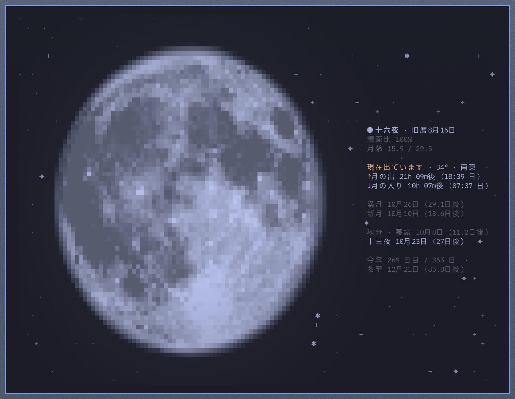
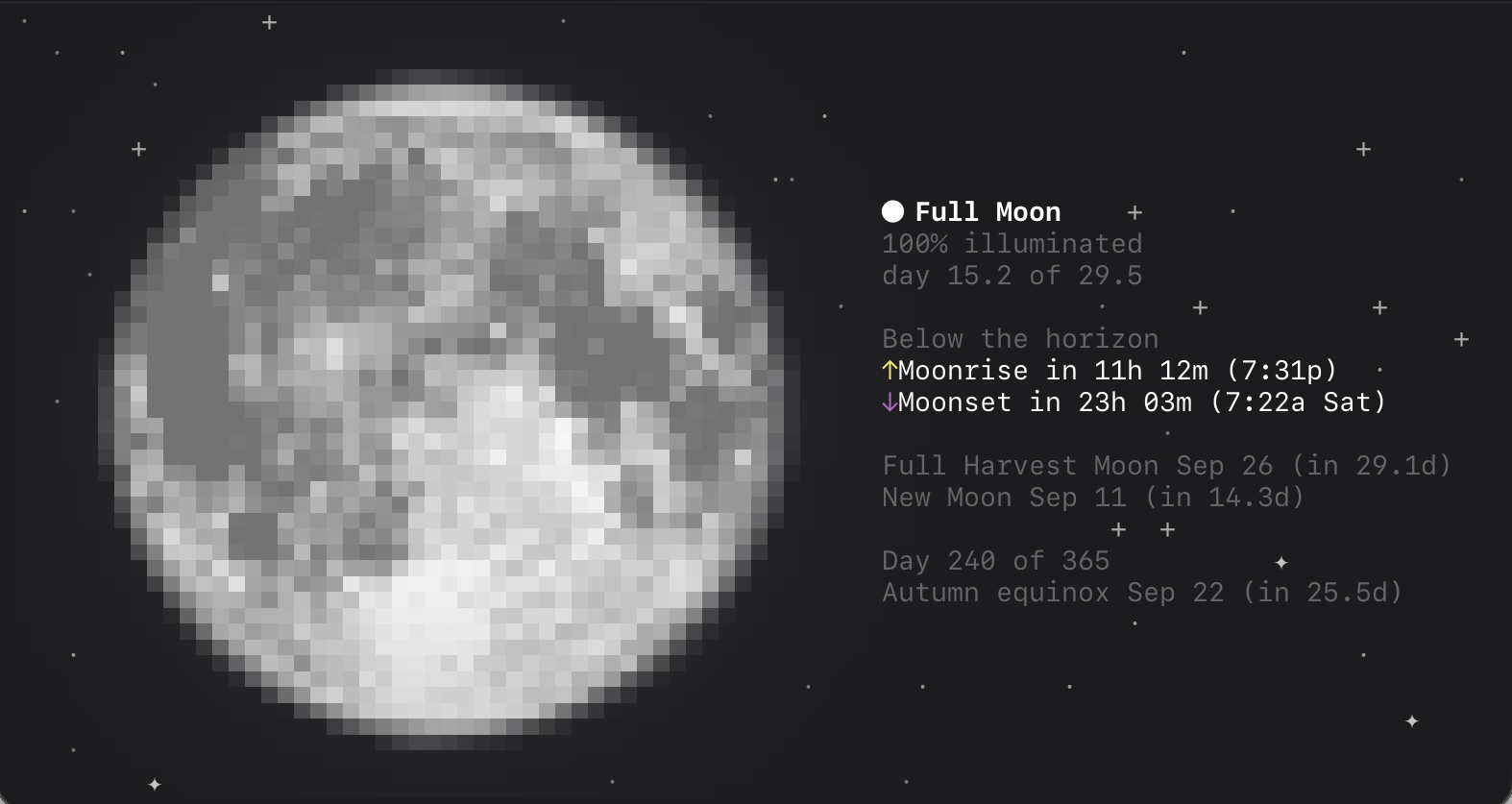
moon draws the current phase as you would see it from your location, with the shadow falling where it really does, the maria shaded, and a halo around it. Scroll to move through time. linecast moon --oneline fits a status bar.
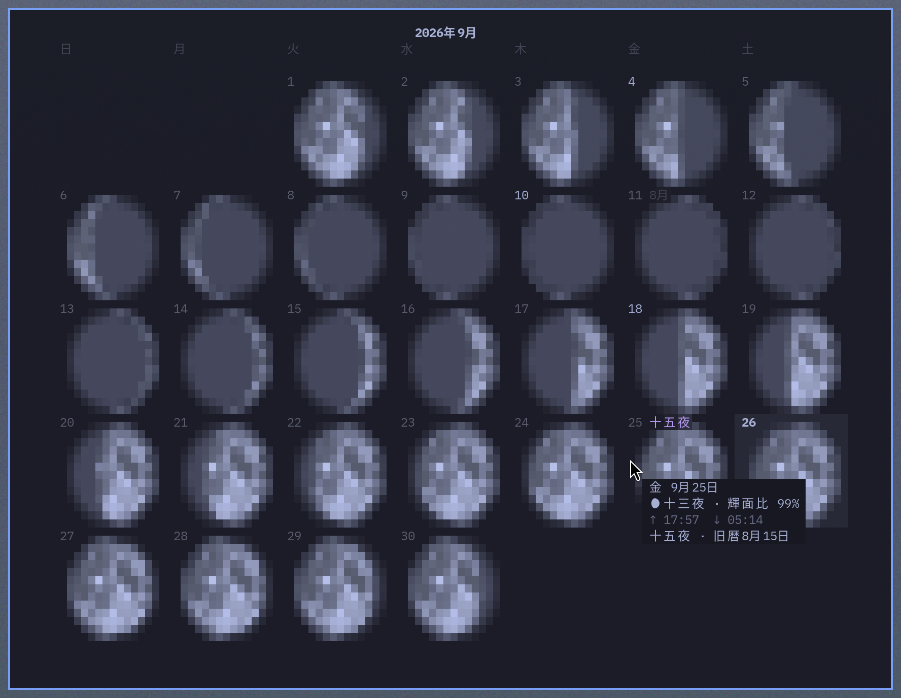
In live mode, v flips to a calendar (or start there with linecast moon --grid): the month laid out week by week, each day carrying its phase as a small shaded disc, with today, the full and new moons, and the quarters marked. Scroll to page through the months, and hover over a day for its phase, moonrise, and moonset. When a traditional calendar is active the grid carries its reading too — the 农历 day names, the lunar month starts, the festivals, the pō mahina — and the pop-up gives the full lunar date. Click a day and the disc view opens on it.
In Chinese, Japanese, and Korean the moon also follows the traditional calendar: the lunar date sits beside the phase name — and in Japanese the night is called by its own name, 十六夜, 居待月, 更待月 — with the solar term in progress and a countdown to the next festival, 中秋节, 추석, or 十五夜. Any language can ask for any of the three with --calendar chinese, japanese, or korean, written with the customary English names ("End of Heat · White Dew Sep 7", "Mid-Autumn Festival Sep 25"). The months, leap months, and solar terms are all computed from the ephemeris at each calendar's own meridian; nothing is looked up.
In Thai the moon follows the Thai lunar calendar, ปฏิทินจันทรคติไทย: the waxing or waning day sits beside the phase in Thai numerals, as the printed calendars have it — แรม ๔ ค่ำ เดือน ๙ — with the year's animal, a countdown to the next วันพระ (the four Buddhist holy days of each month), and the coming festival, มาฆบูชา through ลอยกระทง. This calendar is arithmetic rather than astronomical: the months run on the old Suriyayart reckoning, in which 800 solar years are exactly 292207 days — the same integer bookkeeping behind every printed Thai calendar, checked against the official holy days of 2023–2026. Any language can ask for it with --calendar thai ("month 9 · waning 4", "Loy Krathong Nov 24").
--calendar hawaiian follows the Kaulana Mahina, which names every night: Hilo, Hoaka, the Kū and ʻOle nights, through Māhealani, Kāne, and Muku, each in its ten-night anahulu — hoʻonui waxing, poepoe round, hōʻemi waning. The month begins at Hilo, the first night the young crescent can be seen, so it is computed as a visibility date — crescent geometry in the evening sky over Hawaiʻi, not a fixed step from the new moon — and checked against every month of the Western Pacific Regional Fishery Management Council's published calendars. The panel carries the Council's counsel for the night — the four monthly kapu periods, the unproductive ʻOle nights, and each anahulu's fishing outlook — quoted from their educational materials, with a Source: wpcouncil.org line under it.
--calendar samoan and --calendar chamorro follow the Council's American Samoa and Guam calendars the same way. Each names thirty nights, Masina Fou through Masina Maunā and Sinahen Håcha through Sinahi, beginning the first evening the crescent can be seen over Pago Pago Harbor or Hagåtña, and each is checked against every month the Council has printed since 2021. --calendar refaluwasch shows the CNMI edition: the CHamoru night with its Refaluwasch name beside it on the eleven nights that tradition names, Sighauru through Arofú. In a few months of the 2021 to 2025 editions the printed start departs from the visibility data it otherwise follows; the tests list them, and every month of the 2026 calendars matches to the night.
--calendar islamic follows the Umm al-Qura calendar, Saudi Arabia's civil calendar, which is the one Islamic calendar a program can compute: since 1423 AH its rule is geometric — a month begins the day after the first sunset at Mecca that follows the new moon with the Moon still above the horizon — and linecast evaluates it from the same ephemeris the rest of the app draws with. Checked against the published calendar for 1423 through 1500 AH, it matches every month but one, in 2006, where the new moon fell five minutes before Mecca's sunset by one reckoning and after it by the other. The Hijri date sits beside the phase (23 Ramadan 1447 AH) and turns at your own sunset, since the Hijri day begins in the evening; the coming month and the next observance follow with their civil dates — Islamic New Year, Ashura, Mawlid, the start of Ramadan, Laylat al-Qadr, Eid al-Fitr, the Day of Arafah, and Eid al-Adha — and on the day before one the countdown says it begins at sunset. The months are transliterated in every language (Indonesian gets its own spellings, Ramadan, Syawal, Zulhijah), and the month grid sets the Hijri months in its title, gives each day's Hijri date in the corner of its cell, and marks each month's first day and the observances. Most countries begin Ramadan and the Eids on a sighting of the crescent, so a country's announced dates may differ from these by a day; Saudi Arabia's own announcements sometimes do.
--calendar hebrew follows the Hebrew calendar, which has been pure arithmetic since the fourth century: the year begins at the mean new moon of Tishrei, moved by the four postponement rules, and a thirteenth month, Adar I, comes seven times in nineteen years. linecast computes it from those rules (Dershowitz and Reingold's Calendrical Calculations is the reference) and the tests pin every month of 5780 through 5790 and every holiday of 2023 through 2026 against Hebcal. The date sits beside the phase (20 Elul 5786) and turns at your own sunset, since the Hebrew day begins in the evening; the coming month and the next holiday follow with their civil dates — Rosh Hashanah, Yom Kippur, Sukkot, Shemini Atzeret, Simchat Torah, Hanukkah, Tu BiShvat, Purim, Pesach, Shavuot, and Tisha B'Av — and on the day before a holiday the countdown says it begins at sunset. The holidays follow the place shown, the way a calendar printed in Jerusalem differs from one printed in Brooklyn: outside Israel a second day of Sukkot, Shavuot, and Pesach's first and last days, and Simchat Torah the day after Shemini Atzeret; in Israel one day each, with Simchat Torah on Shemini Atzeret itself. Hebrew is not one of the app's languages, so the months and holidays are transliterated in every language; the month grid sets the Hebrew months in its title, gives each day's Hebrew date in the corner of its cell, names each holiday's days, and marks the month starts, and the hover chip notes each Rosh Chodesh. --json adds the date in Hebrew letters as well, כ׳ אלול תשפ״ו, for a consumer that can lay Hebrew out.
--calendar almanac reads the moon the way the Old Farmer's Almanac does — the same kind of tradition, from the English-language side: the light or dark of the moon beside the phase, what each half favors in the garden, and the day's solunar activity periods — the majors when the Moon crosses the meridian above or below, the minors at moonrise and moonset. The almanac's full-moon names (Harvest, Wolf, and the rest) belong to it too: they show there and in the plain English view, while a panel following another tradition's calendar keeps the plain phase name.
Point sunshine or moon somewhere across an ocean and the rise and set times come back in that place's local clock.
Tides
The tide chart runs across several days and marks the highs, the lows, and the current predicted water level. Scroll to move through time.
Predictions come from the national services where they exist — NOAA in the US, the Canadian Hydrographic Service, Queensland Open Data, and the Hong Kong Observatory — and from Open-Meteo's global tide model everywhere else. An optional TideCheck key adds more named stations. linecast tides --nearby lists the closest stations; linecast tides --station <id or name> pins one.
Radar
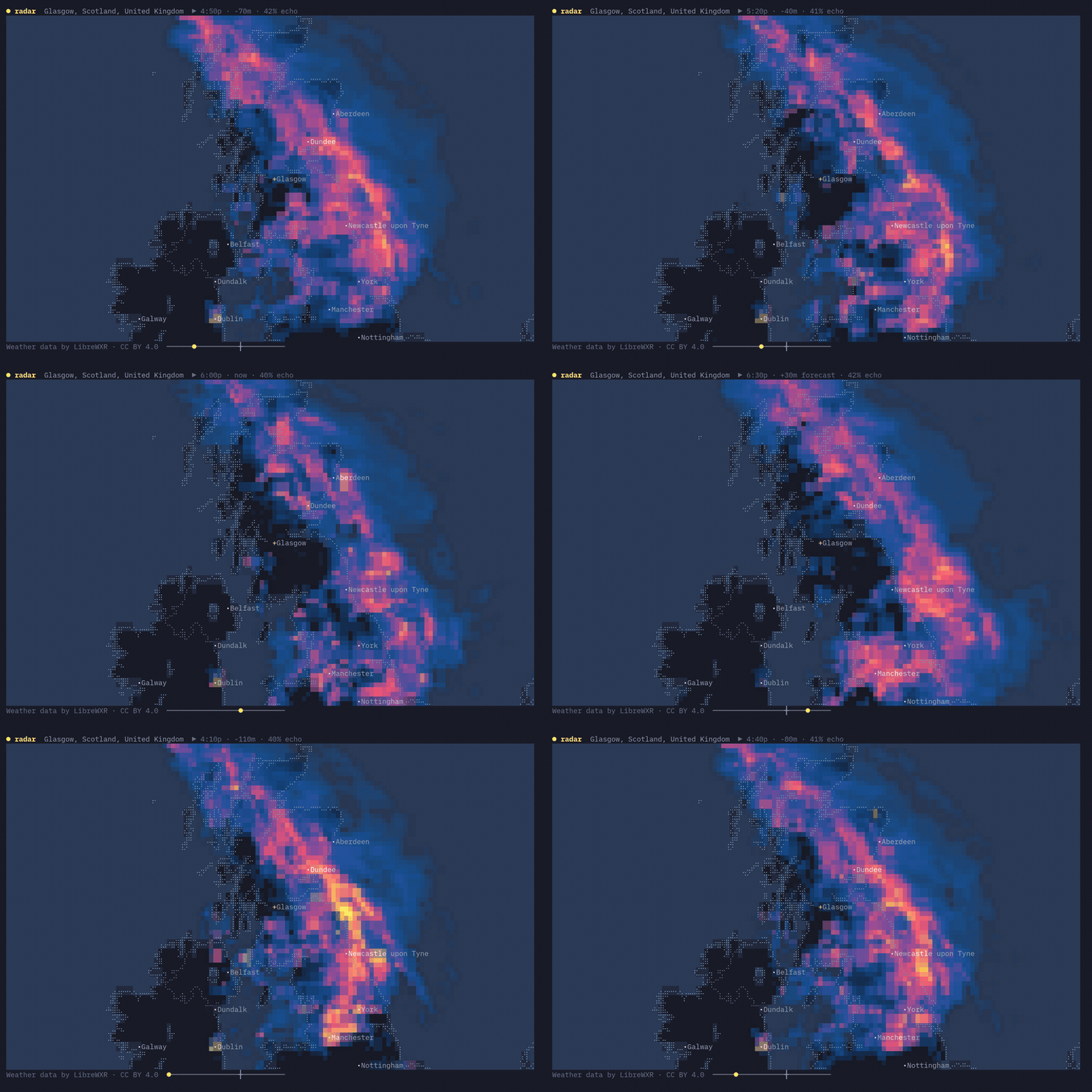
Radar animates recent observations and an hour of forecast over a braille basemap.
Real radar exists only where open composites are published: North America, Europe, and parts of East and Southeast Asia. Elsewhere, LibreWXR fills in with a precipitation model, and it looks like one. US warning polygons are drawn too, along with optional temperature and wind layers and hourly infrared satellite imagery.
Rain is drawn in colors taken from your terminal theme; if the theme is monochrome, so is the rain. There are a few fixed themes as well — dusk, ember, ink, and marangai — plus LibreWXR's server-rendered ones. Press t to switch.
linecast radar --theme dusk
linecast radar --layers temp,wind
linecast radar --layer satellite
--source librewxr, --source rainviewer, or --source iem pins one frame source instead of routing by location, for comparing what each shows over the same spot.
Maps
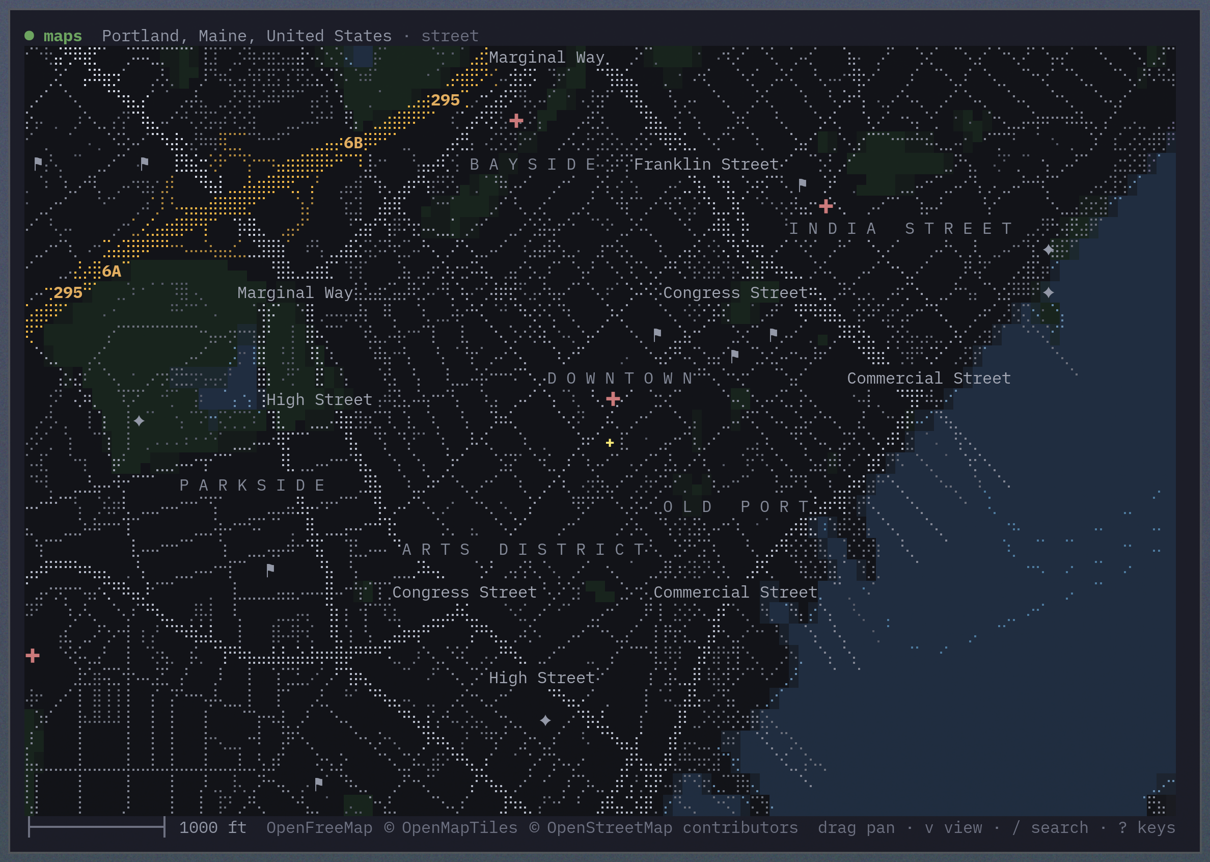
Maps draws the streets in braille over water, land, parks, and buildings filled in solid color.
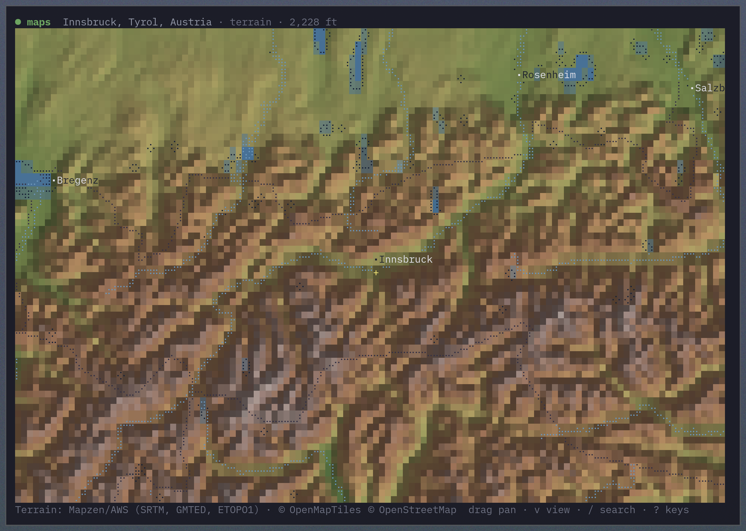
In terrain view, the land is shaded by height and lit from one side, like a relief map. Coastlines, borders, water, and cities are drawn over it in braille; l toggles them and the labels.
Search with / and ask for directions with d. Directions open as a panel of turn-by-turn steps; arrow or click through them and the map flies along the route.
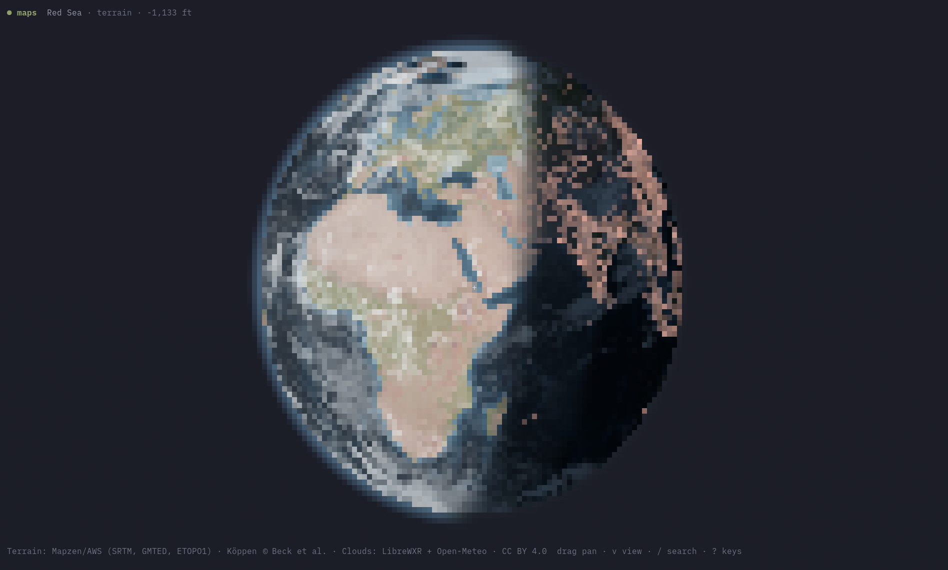
Zoom all the way out and either view becomes a globe you can rotate by dragging, or set spinning with r. Two keys switch on the sky as it is right now: s shades the planet into actual daylight, with a creeping terminator and cities glowing on the night side, and c lays the current global cloud cover over it from live satellite imagery. linecast maps --view now opens straight to the full picture.
Everything is a single key — ? shows this list in the app:
| Keys | |
|---|---|
| drag · wheel · hover | pan, zoom at the pointer, identify what's under the cursor |
+ - |
zoom |
n |
back to the start view |
v l |
street ↔ terrain · toggle labels & lines |
s c |
daylight and night city lights · live cloud cover |
r |
spin the globe |
/ |
search places and addresses |
d o p |
directions · set the origin · cycle travel mode |
q |
quit |
linecast maps --location "Portland, Maine" --zoom 0.01
linecast maps --view terrain --location 60.4,5.3 --zoom 8
linecast maps --view now
linecast maps --from "Gorham, Maine" --to "Portland Head Light" --profile foot
Make it yours
Settings live in ~/.config/linecast/config.json. For any of them, a command-line flag beats an environment variable, which beats the saved setting.
Location
Save one location for every command:
linecast location set "Portland, Maine"
linecast location set "westbrook, maine"
linecast location set 44.54,-68.42
linecast location
linecast location auto
linecast location search fayette
set takes a place name or exact lat,lng coordinates. A name is looked up once, on the spot, and the first match is saved; search lists the candidates when the first match might not be the right one. A command's --location flag or WEATHER_LOCATION wins over the saved location.
With no location saved or passed, linecast falls back to IP geolocation: a single anonymous request to ipinfo.io (or to ipwho.is or GeoJS if it doesn't answer), which returns the rough position of your network connection — usually the right city, sometimes the wrong one, and off by a lot on a VPN or corporate network. The answer is cached for an hour. Save a location, or set any override, and the request is not made at all.
Units
Units follow the location: imperial in the United States, metric everywhere else. Either can be pinned for every command:
linecast units metric
linecast units imperial
linecast units
linecast units auto
Every view command takes --metric and --imperial; weather adds --celsius and --fahrenheit for the temperature alone. LINECAST_UNITS sets units for every command; WEATHER_UNITS and TIDES_UNITS override it for their one command.
Clock
The clock tries to follow the country: 12-hour in the United States, Canada, Australia, and the other places that write 6:50 pm, 24-hour everywhere else. Pin either for every command:
linecast clock 12
linecast clock 24
linecast clock
linecast clock auto
The time-showing commands take --12h and --24h for one run, and LINECAST_CLOCK sets it in the environment.
Language
Use --lang or LINECAST_LANG to pick the language. There are eighteen:
English, French, Spanish, German, Italian, Portuguese, Dutch, Polish, Norwegian, Swedish, Icelandic, Danish, Finnish, Japanese, Korean, Chinese, Thai, and Indonesian
linecast weather --lang fr
linecast radar --lang zh
In India, alerts go one step further: SACHET publishes many of them in the state language, and --lang hi, te, or, mr, or another Indian language code shows that regional text where it exists, while the rest of the app stays in English.
Calendar
The moon's traditional calendar follows the language: Chinese with --lang zh, Japanese with ja, Korean with ko, Thai with th, none otherwise. Pin one — the Pacific calendars, the Islamic and Hebrew calendars, and the Old Farmer's Almanac included — or none, for every run:
linecast calendar chinese
linecast calendar thai
linecast calendar hawaiian
linecast calendar samoan
linecast calendar chamorro
linecast calendar refaluwasch
linecast calendar islamic
linecast calendar hebrew
linecast calendar almanac
linecast calendar none
linecast calendar
linecast calendar auto
moon takes --calendar for one run.
Color and icons
linecast asks the terminal for its palette so its colors belong in your theme. Set LINECAST_COLOR to truecolor, 256, 16, or none to choose the color mode yourself, or use the standard NO_COLOR variable.
Icons come in three sets: Nerd Font glyphs in terminals that bundle them (WezTerm, kitty, Ghostty), emoji in other terminals, and plain Unicode when output is piped. If you have installed a Nerd Font in Alacritty, foot, or iTerm2, linecast cannot tell, so say so once:
linecast icons nerd
linecast icons emoji
linecast icons plain
linecast icons
linecast icons auto
--icons and LINECAST_ICONS pick a set for one run, and linecast doctor shows a glyph from each so you can see what your font renders.
Short names
If you'd rather type weather than linecast weather, linecast link makes weather, sunshine, moon, tides, radar, and maps as links beside the linecast binary, skipping any name something else already owns; linecast link --remove takes them away. A shell alias does the same job.
Shell completion
# Bash
source <(linecast completion bash)

# Zsh
source <(linecast completion zsh)

# Fish
linecast completion fish | source

# Nushell
linecast completion nu | save -f ~/.config/nushell/completions/linecast_completions.nu
# in config.nu:
use ~/.config/nushell/completions/linecast_completions.nu *
Completion covers linecast <command> and the short names, for anyone who aliased or linked them.
When something looks wrong
linecast doctor
linecast doctor --offline
linecast doctor --json
linecast doctor reports the build, the settings and cache paths, what the terminal advertised, which settings are in force and where each came from, and whether each data provider answered. Secrets show as "(set)", never their value. --offline skips the probes; --json is the thing to paste into a bug report.
The six view commands and linecast doctor take --debug, which prints a line on stderr for each fallback taken along the way — a provider that did not answer, a tile that would not decode — and what was shown instead.
Environment variables
| Variable | Description |
|---|---|
WEATHER_LOCATION |
Default location for location-aware commands, as lat,lng or a place name; overrides the saved location |
WEATHER_UNITS |
metric or imperial for the weather command; overrides LINECAST_UNITS and the saved units |
TIDE_STATION |
Default tide station ID |
TIDES_UNITS |
metric or imperial for tide heights; overrides LINECAST_UNITS and the saved units |
LINECAST_UNITS |
metric or imperial for every command; overrides the saved units |
LINECAST_CLOCK |
12 or 24; overrides the saved clock |
LINECAST_TIDECHECK_KEY |
Optional TideCheck API key for global tide coverage |
LINECAST_TIDECHECK_PAID |
Set to 1 on a paid TideCheck plan; the request tally then drops the 50-a-day free-tier cap |
LINECAST_LANG |
UI language code: en, fr, es, de, it, pt, nl, pl, no, sv, is, da, fi, ja, ko, zh, th, or id |
LINECAST_RADAR_THEME |
Default radar color theme |
LINECAST_RADAR_SOURCE |
Pin the radar frame source: librewxr, rainviewer, or iem |
LINECAST_RADAR_LAYER |
radar (default) or satellite, the imagery radar opens with |
LINECAST_RADAR_LAYERS |
Overlays radar opens with, temp, wind, or both comma-separated |
LINECAST_SUNSHINE_YEAR_PALETTE |
dial (default) for the Solar Dial colors in sunshine --year, or graph for the day view's own sky |
LINECAST_LIBREWXR_URL |
Base URL of a self-hosted LibreWXR instance |
LINECAST_VECTOR_TILES_URL |
TileJSON URL of a self-hosted street tile server, used instead of OpenFreeMap with no fallback |
LINECAST_ELEVATION_URL |
Elevation tile source for maps: a bucket root holding terrarium/{z}/{x}/{y}.png, or a full tile URL template containing {z}, {x}, and {y} |
LINECAST_ICONS |
icon set: nerd, emoji, or plain; overrides the saved icons (default: nerd where the terminal bundles the glyphs, emoji on other interactive terminals, plain when piped) |
LINECAST_COLOR |
auto, truecolor, 256, 16, or none |
LINECAST_THEME |
auto (default), or classic / legacy / off for the fixed palette |
LINECAST_THEME_TIMEOUT_MS |
Terminal palette query timeout in milliseconds (default 100) |
LINECAST_THEME_POLL |
Seconds between re-reading the terminal palette in live views, so a theme switch re-inks the view in place (default 2; 0 disables) |
LINECAST_THEME_WATCH |
A file whose modification marks a desktop theme change, prompting an immediate re-read (default: Omarchy's current-theme marker; empty disables) |
LINECAST_CACHE_DIR |
Directory for cached data, used exactly as given |
LINECAST_MAPS_CACHE_MB |
Size the map tile cache is swept back to when maps starts (default 256) |
LINECAST_CONFIG_DIR |
Directory for config.json, used exactly as given |
NO_COLOR |
Any non-empty value disables ANSI colors |
CLICOLOR / CLICOLOR_FORCE |
CLICOLOR=0 disables color; a non-zero CLICOLOR_FORCE keeps it on when output is not a terminal |
Cached data lives in ~/Library/Caches/linecast on macOS and ~/.cache/linecast elsewhere; settings in ~/.config/linecast/config.json. Both honor the XDG_* variables, and the LINECAST_*_DIR variables above override everything.
Data sources and coverage
- Location — ipinfo.io for IP geolocation when no location is saved or passed, with ipwho.is and GeoJS as fallbacks; place names are geocoded by Open-Meteo, with Photon as a fallback.
- Weather — Open-Meteo for forecasts, geocoding, and air quality. Alerts come from the US National Weather Service, Environment Canada, China Meteorological Administration, DWD via Bright Sky, Hong Kong Observatory, Met Éireann, Japan Meteorological Agency, MET Norway, MetService New Zealand, MeteoAlarm (with its warning-region geometry vendored, © EUMETNET, CC BY 4.0, the NUTS regions some feeds file from Eurostat GISCO, © EuroGeographics for the administrative boundaries, and Czechia's ORP boundaries from ČÚZK RÚIAN with the Czech Statistical Office's code list, both open data), and SACHET (India's national alert aggregator).
- Sunshine and Moon — computed on your device from the astronomical equations; the Moon's face is a vendored grayscale of NASA SVS's CGI Moon Kit (Lunar Reconnaissance Orbiter, public domain).
- Tides — NOAA CO-OPS, Canadian Hydrographic Service, Queensland Open Data, Hong Kong Observatory, Open-Meteo's tide model as a global fallback, and optionally TideCheck.
- Radar — LibreWXR, with NEXRAD via Iowa Environmental Mesonet and RainViewer as fallbacks; warning polygons come from the US National Weather Service via IEM. The basemap is derived from Natural Earth.
- Maps — terrain from AWS/Mapzen elevation tiles; streets and inland water from OpenFreeMap vector tiles (© OpenMapTiles © OpenStreetMap contributors), with the OpenStreetMap US Tileservice as a fallback (Tiles by OSM US); search from Photon and Nominatim; directions from FOSSGIS OSRM (© OpenStreetMap contributors); globe cloud cover from LibreWXR (CC BY 4.0) satellite imagery; terrain color picks its ramp from a vendored Köppen-Geiger climate grid (Beck et al. 2023, CC BY 4.0).
Contributing
Pull requests are welcome. ARCHITECTURE.md is the map of the code. The suite runs with uv run --with pytest pytest tests -q and the lint with uvx ruff check src tests scripts; both are meant to run without the network and without touching your home directory.
Lineage
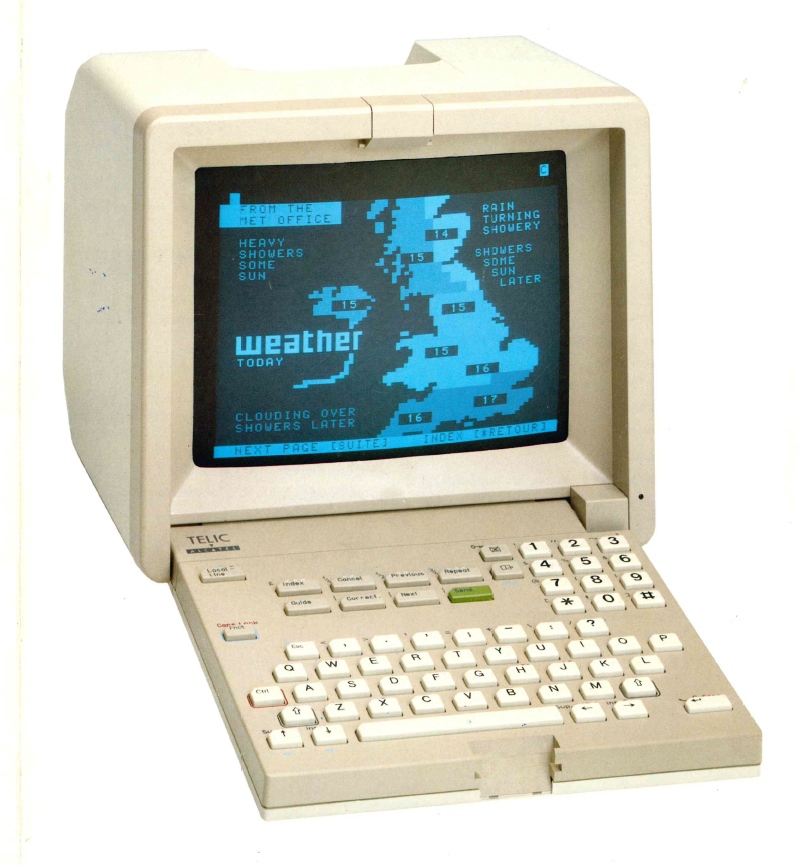
Prior art.
A Telic-Alcatel videotex terminal draws the weather, circa 1990. Photograph from the collection at minitel-alcatel.fr.
License
1 maintainer

Download files
Download the file for your platform. If you're not sure which to choose, learn more about installing packages.
Source Distribution
Built Distribution
Filter files by name, interpreter, ABI, and platform.
If you're not sure about the file name format, learn more about wheel file names.
Copy a direct link to the current filters
File details
Details for the file linecast-2.3.0.tar.gz.
File metadata
- Download URL: linecast-2.3.0.tar.gz
- Upload date:
- Size: 6.4 MB
- Tags: Source
- Uploaded using Trusted Publishing? Yes
- Uploaded via:
twine/7.0.0 CPython/3.13.14
File hashes
| Algorithm | Hash digest | |
|---|---|---|
| SHA256 |
65267e70821901c6c6901d94969e21928670b4deece4f366e3951f8837237140
|
|
| MD5 |
57a2f7e0ed49065bdcadec42b2b32017
|
|
| BLAKE2b-256 |
cdf1b8881fd4fc0ab3b4584ef239ff4c05305bc5825909195c0f5c699f5b8c59
|
Provenance
The following attestation bundles were made for linecast-2.3.0.tar.gz:
Publisher:
publish.yml on ashuttl/linecast
-
Statement:
-
Statement type:
https://in-toto.io/Statement/v1 -
Predicate type:
https://docs.pypi.org/attestations/publish/v1 -
Subject name:
linecast-2.3.0.tar.gz -
Subject digest:
65267e70821901c6c6901d94969e21928670b4deece4f366e3951f8837237140 - Sigstore transparency entry: 2688952286
- Sigstore integration time:
-
Permalink:
ashuttl/linecast@7fdd1d61c3b5079b512170c3e96c7b3543f30669 -
Branch / Tag:
refs/tags/v2.3.0 - Owner: https://github.com/ashuttl
-
Access:
public
-
Token Issuer:
https://token.actions.githubusercontent.com -
Runner Environment:
github-hosted -
Publication workflow:
publish.yml@7fdd1d61c3b5079b512170c3e96c7b3543f30669 -
Trigger Event:
push
-
Statement type:
File details
Details for the file linecast-2.3.0-py3-none-any.whl.
File metadata
- Download URL: linecast-2.3.0-py3-none-any.whl
- Upload date:
- Size: 6.1 MB
- Tags: Python 3
- Uploaded using Trusted Publishing? Yes
- Uploaded via:
twine/7.0.0 CPython/3.13.14
File hashes
| Algorithm | Hash digest | |
|---|---|---|
| SHA256 |
0d3a14e51b487bea96285898224b7cae34b67578f6518066c0a35ff724a3eb34
|
|
| MD5 |
89e0bd6231183e394ab837d03d9f5c69
|
|
| BLAKE2b-256 |
71163a5ff865b728cc275019d2c2ff1d4335ce6af529c5d08bde5ea48a0517ec
|
Provenance
The following attestation bundles were made for linecast-2.3.0-py3-none-any.whl:
Publisher:
publish.yml on ashuttl/linecast
-
Statement:
-
Statement type:
https://in-toto.io/Statement/v1 -
Predicate type:
https://docs.pypi.org/attestations/publish/v1 -
Subject name:
linecast-2.3.0-py3-none-any.whl -
Subject digest:
0d3a14e51b487bea96285898224b7cae34b67578f6518066c0a35ff724a3eb34 - Sigstore transparency entry: 2688952305
- Sigstore integration time:
-
Permalink:
ashuttl/linecast@7fdd1d61c3b5079b512170c3e96c7b3543f30669 -
Branch / Tag:
refs/tags/v2.3.0 - Owner: https://github.com/ashuttl
-
Access:
public
-
Token Issuer:
https://token.actions.githubusercontent.com -
Runner Environment:
github-hosted -
Publication workflow:
publish.yml@7fdd1d61c3b5079b512170c3e96c7b3543f30669 -
Trigger Event:
push
-
Statement type:














